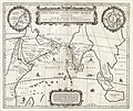
File:1658 Jansson Map of the Indian Ocean (Erythrean Sea) in Antiquity - Geographicus - ErythraeanSea-jansson-1658.jpg

Contenuti della pagina non supportati in altre lingue.
À prupositu di Wikipedia

Imagine in alta resoluzione(5 000 × 4 194 pixel, dimensione del file: 6,03 MB, tipo MIME: image/jpeg)

Questo file proviene da Wikimedia Commons e può essere utilizzato da altri progetti. Di seguito viene mostrata la descrizione presente nella pagina di descrizione del file.

Johannes Janssonius: Erythraei Sive Rubri Maris Periplus.   (Wikidata search (Cirrus search) Wikidata query (SPARQL)  Create new Wikidata item based on this file)
Artista
Johannes Janssonius  (1588–1664)  wikidata:Q949492 s:it:Autore:Johannes Janssonius
 
Nomi alternativi
Jan Jansson, Jan Jansz, Jan Janszoon, Joannes Janssonius
Descrizione cartografo, editore è mercante di stampe olandese
Data di nascita/morte 1588 Modifica su Wikidata 11 lugliu 1664 / 1664 Modifica su Wikidata
Luogo di nascita/morte Arnhem Amsterdam
Periodo di attività dal 1616 al 1664
date QS:P,+1650-00-00T00:00:00Z/7,P580,+1616-00-00T00:00:00Z/9,P582,+1664-00-00T00:00:00Z/9
Luogo di attività
Amsterdam (1612–1664); Arnhem (1612–1612) Modifica su Wikidata
Authority file
artist QS:P170,Q949492
Titolo
Erythraei Sive Rubri Maris Periplus.
Descrizzione
English: An unusual and attractive 1658 map of the Indian Ocean, or Erythraean Sea, as it was in antiquity. Composed by Jan Jansson after a similar 1597 map published by A. Ortelius in his Parergon . Covers from Egypt and the Nile valley eastward past Arabia and India, to Southeast Asia and Java. Cartographically, India, Arabia, and Africa roughly correspond to the conventions of the period. Southeast Asia is less recognizable, but the Malay Peninsula, Sumatra, and Java are clearly noted. Most of the place names used throughout are derived from Ptolemy, who himself based his description of the region heavily on records from Alexander the Great's conquests. Two smaller maps in the upper left and right quadrants are of exceptional interest. The upper left chart shows northwestern Africa and is titled Annonis Periplus. This is a reference to the legendary expeditions of the Carthaginian King Hanno, said to have been the first to access the Indian Ocean by sailing around the southern tip of Africa. Incidentally, en route, he is also said to have been the first to tame a lion. The upper right chart shows the northern polar regions as they were perceived at the time. A landmass covering the polar ice cap is indentified as Hyperborea. To the left of this, roughly where North America rests today, the island of Atlantis appears; while Scythia, Europe (Thule) and Asia are on the right. Greenland and possibly Iceland appear at the bottom. This map is intended to point out the possibility of a Northeast Passage to Asia, which was at the time being actively sought after by Dutch, English, and Russian navigators. Both smaller maps, the primary title area at top center, and an Latin explanation for the map at bottom center, are surrounded by baroque strapwork style borders. This remarkable map was published in volume six, the Orbis Antiquus , of Jan Jansson's Novus Atlas .
Data 1658 (undated)
Dimensioni altezza: 16 pollici (40,6 cm); larghezza: 19 pollici (48,2 cm)
dimensions QS:P2048,16U218593
dimensions QS:P2049,19U218593
Numero d'inventario
Geographicus link: ErythraeanSea-jansson-1658
Fonte/Fotografo

Jansson, J., Novus Atlas, Sive Theatrum Orbis Terrarum: In quo Orbis Antiquus, Seu Geographia Vetus, Sacra & Profana exhibetur, Volume 6, 1658.

Permessu
(Riusare questo file)
Questa è una fedele riproduzione fotografica di un'opera d'arte bidimensionale originale. L'opera d'arte fotografata è nel pubblico dominio per la seguente ragione:
Public domain

Quest'opera è nel pubblico dominio anche in tutti i Paesi e nelle aree in cui la durata del copyright è la vita dell'autore più 100 anni o meno.


Devi inserire anche un tag per il pubblico dominio relativo agli Stati Uniti per indicare perché quest'opera è nel pubblico dominio negli Stati Uniti.
La posizione ufficiale presa dalla Wikimedia Foundation è che le riproduzioni fedeli di opere d'arte bidimensionali nel pubblico dominio siano da considerare anch'esse nel pubblico dominio, e che qualsiasi affermazione contraria rappresenta un attacco al concetto stesso di pubblico dominio ("faithful reproductions of two-dimensional public domain works of art are public domain, and that claims to the contrary represent an assault on the very concept of a public domain"). Per maggiori dettagli, vedi Commons:When to use the PD-Art tag.
Questa riproduzione fotografica è di conseguenza da considerarsi nel pubblico dominio. Per favore, fai attenzione al fatto che, a seconda delle leggi locali, il riutilizzo di questo contenuto potrebbe essere proibito o limitato nella tua giurisdizione. Vedi Commons:Reuse of PD-Art photographs.

Didascalie

Aggiungi una brevissima spiegazione di ciò che questo file rappresenta

Elementi ritratti in questo file

raffigura talianu

tipo di file talianu

image/jpeg

checksum talianu

cad73cb9d07e5064c0b7cbc491e54f6d6b0b9261

metodo di determinazione talianu: SHA-1 talianu

6 324 965 byte

altezza talianu

4 194 pixel

larghezza talianu

5 000 pixel

Cronolugia di l'imagine

Fare clic su un gruppo data/ora per vedere il file come si presentava nel momento indicato.

Data/ÓraPrevisualizzazioneDimensioneCuntributoreCummentu
attuale20:58, 23 mar 2011Previsualizzazione di a versione di5 000 × 4 194 (6,03 MB)BotMultichillT{{subst:User:Multichill/Geographicus |link=http://www.geographicus.com/P/AntiqueMap/ErythraeanSea-jansson-1658 |product_name=1658 Jansson Map of the Indian Ocean (Erythrean Sea) in Antiquity |map_title=Erythraei Sive Rubri Maris Periplus. |description=An

La seguente pagina usa questo file:

Usu glubale di u schedariu

Anche i seguenti wiki usano questo file: