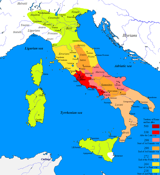
File:Roman conquest of Italy.PNG

Dimensioni di questa anteprima: 550 × 600 pixel. Altre risuluzioni: 220 × 240 pixel | 440 × 480 pixel | 704 × 768 pixel | 1 100 × 1 200 pixel.
Imagine in alta resoluzione (1 100 × 1 200 pixel, dimensione del file: 125 KB, tipo MIME: image/png)
Cronolugia di l'imagine
Fare clic su un gruppo data/ora per vedere il file come si presentava nel momento indicato.
| Data/Óra | Previsualizzazione | Dimensione | Cuntributore | Cummentu | |
|---|---|---|---|---|---|
| attuale | 15:42, 27 dic 2018 |  | 1 100 × 1 200 (125 KB) | Hohum | Carthage not part of Roman conquest of Italy |
| 18:28, 26 nuv 2013 |  | 1 100 × 1 200 (111 KB) | Enok | Reverted to version as of 18:22, 17 October 2011 | |
| 03:06, 23 ghju 2013 |  | 1 100 × 1 200 (111 KB) | Enok | ||
| 01:28, 17 nuv 2011 |  | 1 100 × 1 200 (111 KB) | OgreBot | (BOT): Reverting to most recent version before archival | |
| 01:28, 17 nuv 2011 |  | 1 100 × 1 200 (111 KB) | OgreBot | (BOT): Uploading old version of file from en.wikipedia; originally uploaded on 2009-06-18 18:40:43 by Javierfv1212 | |
| 01:28, 17 nuv 2011 |  | 1 100 × 1 200 (96 KB) | OgreBot | (BOT): Uploading old version of file from en.wikipedia; originally uploaded on 2009-06-18 01:10:30 by Javierfv1212 | |
| 18:22, 17 utt 2011 |  | 1 100 × 1 200 (111 KB) | .marc. | {{Information |Description = Map of the Roman take over of Italy. |Source = Javierfv1212 created this work entirely by himself. Src: Historical Atlas of Ancient Rome, Nick Constable & Penguin Atlas of Ancient Rome. |D |
Ligami
Le seguenti 3 pagine usano questo file:
Usu glubale di u schedariu
Anche i seguenti wiki usano questo file:
- Usu nantu à ar.wikipedia.org
- Usu nantu à azb.wikipedia.org
- Usu nantu à bg.wikipedia.org
- Usu nantu à ca.wikipedia.org
- Usu nantu à cs.wikipedia.org
- Usu nantu à cv.wikipedia.org
- Usu nantu à el.wikipedia.org
- Usu nantu à en.wikipedia.org
- Roman Republic
- 264 BC
- 218 BC
- 500s BC (decade)
- Calabria
- Magna Graecia
- Outline of ancient Rome
- 338 BC
- 298 BC
- 272 BC
- 290 BC
- Samnite Wars
- Campaign history of the Roman military
- Pyrrhic War
- Two-front war
- List of Roman external wars and battles
- Picentes
- History of Rome
- User:Comic master/Rising Powers
- User:Fornadan/temp/overview
- Roman expansion in Italy
- Gnaeus Fulvius Maximus Centumalus
- Quintus Publilius Philo
- Spread of the Latin script
- User:Falcaorib
- User:KarenGrigMan/Roman Republic
- Usu nantu à eo.wikipedia.org
- Usu nantu à es.wikipedia.org
- Usu nantu à et.wikipedia.org
- Usu nantu à fa.wikipedia.org
- Usu nantu à fi.wikipedia.org
- Usu nantu à fr.wikipedia.org
Visualizza l'utilizzo globale di questo file.

